Friday, December 30, 2011

Lunar Calendars

Every year I think I should make a calendar, but I never do... though I do tend to gather a bunch of proofs of my prints to make a calendar just for our home. This year I went so far as to work on a design of a lunar calendar. I think that there is too much information to easily capture in a relief print (unless made on an impractical scale) and that this is something better suited to screenprinting or digital prints. Further, the more I worked on it, the more convinced I became that this was something I should be programming, rather than making by hand.

Here are a few of the lovely 2012 lunar calendars I was able to find.


Lunar Calendar 2012 Poster
Silkscreen over Black paper 240 g/m² 48x66cm
Made with programming using Nodebox
Lunar Calendar, Moon Calendar, Calendário Lunar
by Brazilian designer Dimitre Lima, available here
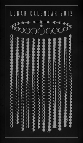
Lunar Calendar 2012

Lunar Calendar 2012
This is a visualization of the lunar calendar for 2012.
columns = months, rows = days.
© Copyright 2011 Michael Paukner.
This doesn't appear to be in his shop right now, but you should check it out (and his photostream) anyway, for lovely design and sciencey goodness!


This calendar on www.ghin.co.uk tries to do it all:
Calendar 2012 is a Gregorian calendar with, moon phases and the Chinese Lunar-solar Calendar integrated, layed out as a circular color wheel. The new additional Chinese calendar is in simplified Chinese.

This years edition of the color wheel calendar marks the End of the Mayan long count. The Maya Long count is the most sophisticated calendar created so far. It consists of different length cycles that makes up the long count which is 5126 years. This long count ends on the winter solstice 21st of December 2012.

Calendar 2012 includes:

- Hebrew, Chinese, Hindu, Buddhist, Gregorian and Islamic year count.
- Fully integrated lunar phase cycle for each day.
- Simplified Chinese Calendar


This calendar is actually from 2011, but you can get the letterpress 2012 version here from lizardpress on Etsy

Saturday, December 24, 2011

Happy Holidays

Whichever of the many December holidays, when days in the Northern Hemisphere grow short and nights are long, which you may celebrate, I hope it's a good one.

These are Mummers in St Johns, Newfoundland and Labrador:


Mummering is a Christmastime tradition in Newfoundland and Labrador, which settlers brought from England at some point. I involves, in various proportions, costumed house visits (sometimes in drag), singing, performance, recitation, challenging hosts to guess identities, and of course, last but not least, drinking.

Tuesday, December 20, 2011

Maps and UnNatural History


The work of Vancouver-based Paul Morstad involves some of my favorite things, and I don't just mean the magpies (as in Magpie Bacchanal, above). His series of multimedia paintings on nautical charts and maps have a sort of chaotic and romantic welter of natural history (flora, fauna, gems and geology) and subtle, imaginative, visual puns.

Consider the ruby-throated hummingbird raising a ruby in her nest.


Humbolt's Acordion seems to allude to one of my favorite, heroic nineteenth century naturalist-explorers, the biologist-meterologist-earth scientist-freedom fighter Alexander von Humboldt, who, amongst many adventures, famously learned 40 words of the dead language of the lost Atures tribe of South America, from a parrot, the last surviving speaker. Though, it isn't impossible it may have just been inspired by accordion players in Humboldt, Saskatchewan (or any number of other places of the same name). It makes me imagine tucans passing on the lost accordion music of some imaginary people. I love how the natural lines of inlets and rivers become trees and branches. I wouldn't have thought forks in rivers were isomorphic to branching in trees, (and I happen to be the sort of person who has spent hours looking at the Canadian Hydrographic Service chart for Jervis Inlet) but the organic lines work so well.


There is something magical and menacing about the regal prairie chicken, over the sedimentary section with cut gem stones, grasshoppers and smoking black-eyed susans in Prospector.


I too am charmed by weather prognosticating rodents.


Paul writes that he is deeply influenced by the "landscapes, people, flora and fauna" of the Western provinces (Saskatchewan, Alberta and British Columbia) where he was raised. Do yourself a favour and check out the rest of his portfolio. I stumbled upon it while looking at some of the animations of his immensely talented sister Julie Morstad; they created the animations together.

Wednesday, December 14, 2011

Tuba


(image: Puffin on a Tuba, by Oliver Lake, available at society6)


This is a strange sort of post. Sometimes I like to gather little themes. This is really just two unusual tuba-related observations this week. Firstly, French cows clearly enjoy some jazz on brass and this tuba and trumpet duo. Made me smile:


(via swissmiss)

Meanwhile, in LA, there have been a rash of tuba thefts, leaving Southlands high schools bereft. Compared to some crime stories in Los Angelos, the idea of banda-crazed theives stealing from high school bands and a tuba-blackmarket seems humourous, but it's actually sad. High schools haven't the budget to replace these instruments. Though, at least these thefts will result in music, not mayheim.

Thursday, December 8, 2011

Stick Charts and Woven Branch Maps


Via I'M REVOLTING come these woven branch maps, described as a collaboration between architect Tim Koelle and an unnamed local Mexican craftsperson (available at mc&co). They (mc&co) explain, "The branches are woven together when freshly cut & flexible. The designs are based on local topographical regions, serving as 'maps'."


I think the branch maps are lovely (if pricey!), but I do think it a bit odd that they do not mention the Polynesian tradition of making maps of branches. To navigate and explore a world of Pacific ocean, sparsely dotted with thousands of small islands, Polynesians created maps with knots, shells and bamboo or coconut fronds to identify routes to islands. They used the sun and stars to identify cardinal directions, and cues such as wave swells, winds, flights of birds, tides, reefs, cloud formation and flotsam to allow them to travel thousands of kilometers in canoes, long before Captain Cooke and other European explorers were able to explore the Pacific. They marked these cues on their maps called Rebbelibs, Medos and Mattangs, or Stick Charts. (You can find more on the history of navigation at sea, including Polynesian and Micronesian methods and maps curtesy of NOAA, the US National Oceanographic and Atmospheric Administration or about stick charts here and here).


I suppose it's possible they are less interested in maps, charts, navigation and the history of science and exploration than I (frankly, it's a bit of an obsession) and they may have actually produced their topographic branch maps in ignorance of Polynesian stick charts through a sort of convergent evolution of design (an idea which in itself interests me). Though, the lovely "Decorative Wall Hangings" might not be a case of cultural appropriation at all, I would far rather have a useful piece of naviation history if I had the choice.

LinkWithin

Related Posts with Thumbnails